
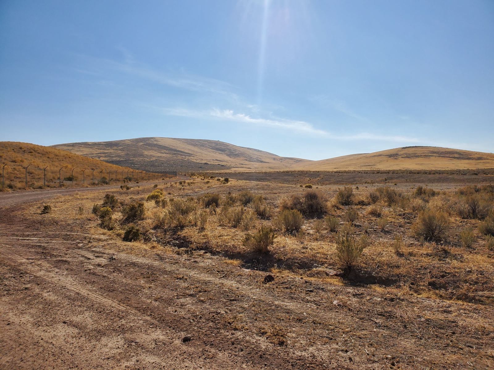
Flagship · Uranium, Vanadium, Molybdenum · 100% owned
Mesa Top Uranium Mine
A past-producing uranium mine property in the Ambrosia Lake subdistrict of the Grants mineral belt — the district that made New Mexico one of the largest uranium producers in the United States. 100% owned and unencumbered.
Overview
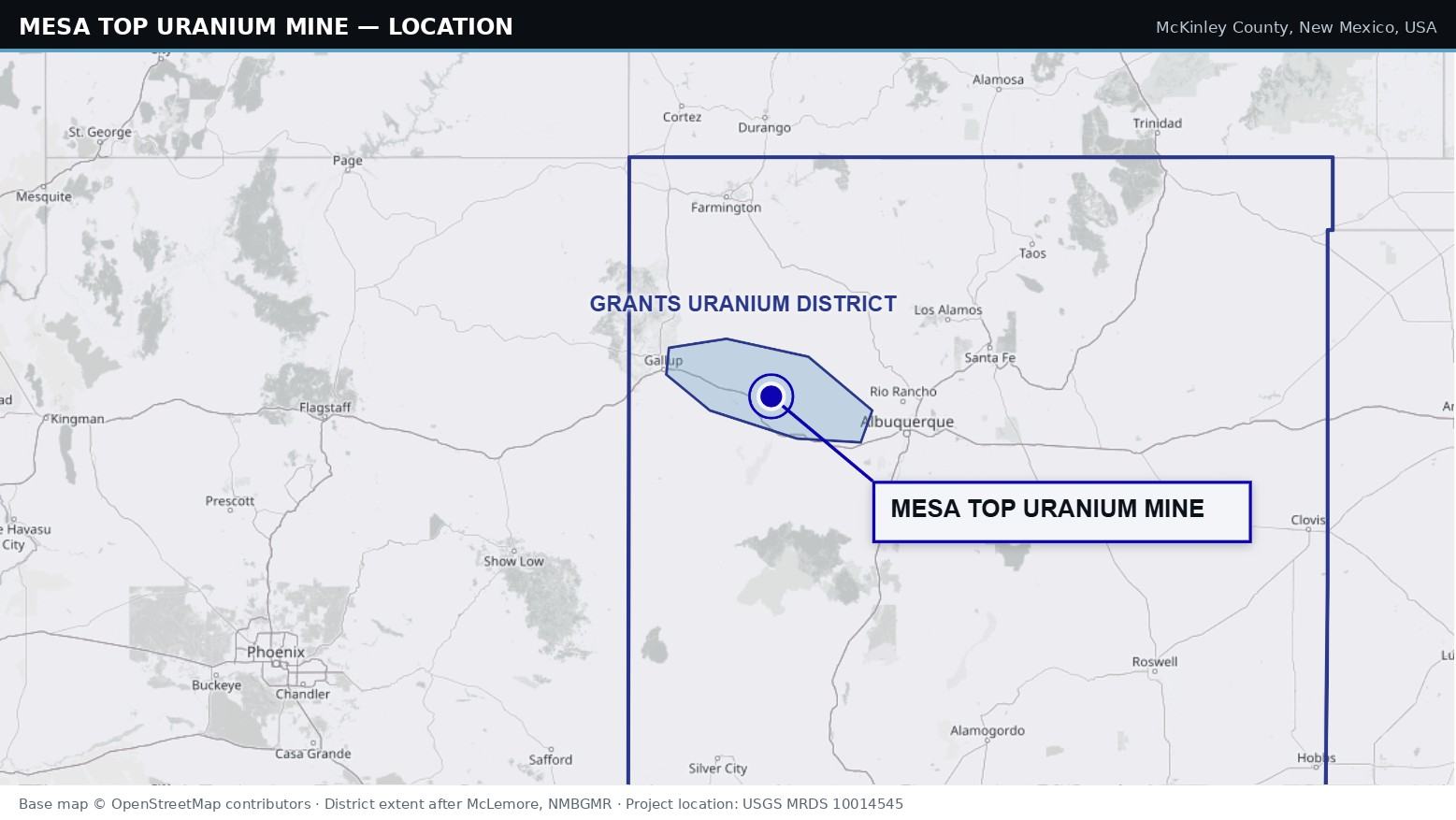
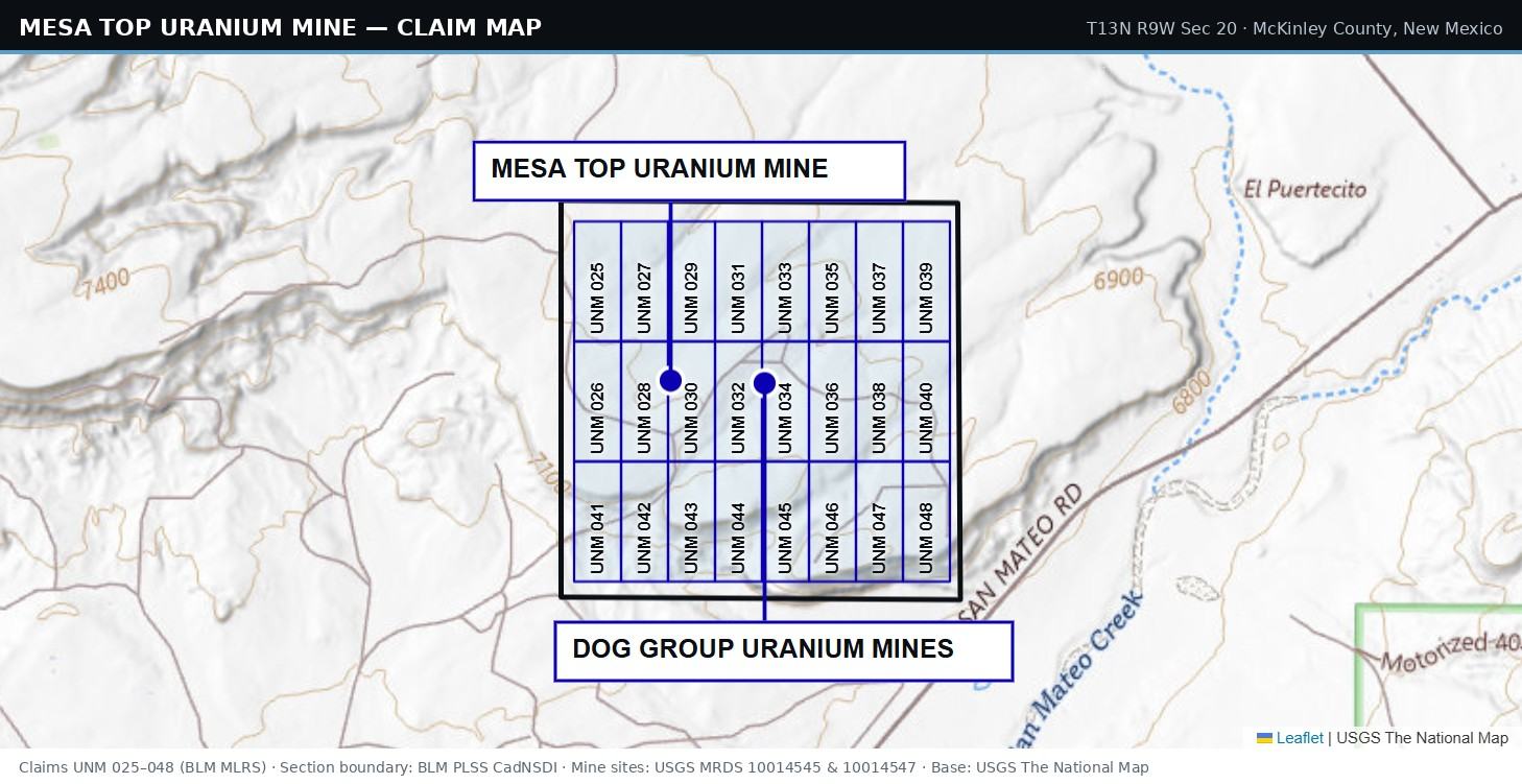
The Mesa Top Uranium Mine project comprises 24 active lode mineral claims totalling approximately 496 acres on Bureau of Land Management land in McKinley County, New Mexico, held through LiVE’s wholly-owned subsidiary Lithium Valley Holdings Corp. The claims are in good standing, with maintenance fees paid through the assessment year ending 1 September 2027.
The property is underlain by sedimentary rocks of the Morrison Formation, representing a Jurassic depositional environment within the Colorado Plateau. The Colorado Plateau is known for sedimentary-hosted uranium deposits consisting of over 1.2 billion pounds of mined and in-situ U3O8. A subsequent assessment estimated 4.4 billion pounds of U3O8 total endowment in the Jurassic Westwater Canyon Member of the Morrison Formation, the main host in the Grants mineral belt.
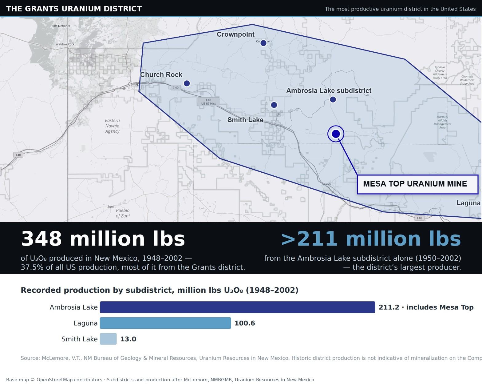
The Grants district produced more uranium than any other district in the United States — New Mexico’s 348 million lbs of U3O8(1948–2002) represented 37.5% of all US production, nearly all of it from the Grants district. The Ambrosia Lake subdistrict, which hosts the Mesa Top Uranium Mine, was the district’s largest producer at more than 211 million lbs.
| Interest | 100%, held through Lithium Valley Holdings Corp. |
|---|---|
| Location | McKinley County, New Mexico, USA |
| District | Grants mineral belt, Ambrosia Lake subdistrict |
| Tenure | 24 lode mineral claims, ~496 acres, BLM land |
| Status | Claims active; fees paid to 1 September 2027 |
| Commodities | Uranium, vanadium, molybdenum |
| Host | Westwater Canyon Member, Morrison Formation |
| Acquired | Announced 1 March 2024 |
Two past-producing mine complexes
USGS Mineral Resources Data System (MRDS) records identify eleven historic mine and prospect sites within the section covered by the claims, resolving into two past-producing complexes with combined recorded production of 352,438 tons of ore between 1954 and 1980 — roughly 1.45 million lbs of contained U3O8, calculated from recorded tonnage and grade.
Mesa Top Uranium Mine MRDS 10014545
Workings consist of open stopes and random pillars with a 200-foot, 45-degree decline shaft, plus two additional shafts.
| Status | Past producer |
|---|---|
| Recorded grade | 0.24% U3O8 |
| Recorded production | 108,261 tons of ore |
| Implied U3O8 | ~520,000 lbs (calculated) |
| Years produced | 1954 – 1968 |
| Discovered | 1953 |
|---|---|
| Discoverer | Holly Uranium Corp., Grants, NM |
| Commodities | Uranium, vanadium, molybdenum |
| Host rock | Poison Canyon sandstone, Brushy Basin Member, Morrison Formation |
| Ore minerals | Carnotite, coffinite, ilsemannite |
Dog Group Uranium Mines MRDS 10014547
Also known as the Dog Incline, Flea Incline and B-6 Group. Workings consist of two decline shafts — the Dog shaft, a 300-foot 30-degree decline, and the Flea shaft, a 380-foot 30-degree decline — with modified room-and-pillar workings.
| Status | Past producer |
|---|---|
| Recorded grade | 0.19% U3O8 |
| Recorded production | 244,177 tons of ore |
| Implied U3O8 | ~928,000 lbs (calculated) |
| Years produced | 1957 – 1980 |
| Discovered | 1956 |
|---|---|
| Commodities | Uranium, molybdenum |
| Ore setting | Oxidized redistributed ore along fractures trending N10–15W |
| Host rock | Poison Canyon sandstone, Brushy Basin Member, Morrison Formation |
Additional named historic workings within the section include the Holly, Beacon Hill and Malpais mines (MRDS 10175272, 10198859, 10198978), each recorded as past producers of uranium, plus satellite and unnamed workings (MRDS 10126062, 10151348, 10199489, 10223362, 10198713, 10199016, 10272027).
Qualified person
Adrian Smith, P.Geo., is a qualified person as defined in National Instrument 43-101 — Standards of Disclosure for Mineral Projects, and has reviewed and approved the scientific and technical information on this page.
Cautionary note
Historic production figures and grades on this page are drawn from public records of historic mining activity in the district and are provided for geological context only. They are not necessarily indicative of mineralization on the Company’s claims. The Company is an exploration stage company and has no mineral resources or reserves on any of its properties. There is no assurance that exploration will result in the delineation of a mineral resource.
References
Historic production, discovery and workings: USGS Mineral Resources Data System (MRDS), deposit ID 10014545 (Mesa Top Mine) and deposit ID 10014547 (Dog Group Mines), with additional records verified within T13N R9W Section 20. Bibliographic references cited in the MRDS case files: Rapaport, I., 1963, NMBMMR Memoir 15, p. 126–129; Hilpert, L.S., 1969, USGS Professional Paper 603, p. 34; McLemore, V.T., 1983, NMBMMR Open-File Report 183, Appendix 1. District production and ranking: McLemore, V.T., New Mexico Bureau of Geology & Mineral Resources, Uranium Resources in New Mexico. District geology and endowment: S.M. Hall, et al., 2023, Sandstone-hosted uranium deposits of the Colorado Plateau, USA, Ore Geology Reviews, Volume 155. Tenure: Bureau of Land Management, Mineral & Land Records System (MLRS) claim records.