
Mesa Top &
Section 20
2 premier New Mexico Uranium projects located within the Colorado Plateau, McKinley County in the Grants District.
Both Properties are located within BLM land and are accessible by roads with proximity to major state highways.
Uranium in a Historic New Mexico District
Located within the prolific Grants mineral belt along the south margin of the San Juan Basin in McKinley and Cibola counties to the northwest part of New Mexico. The Grants mineral belt is host to the majority of Uranium discoveries within the state
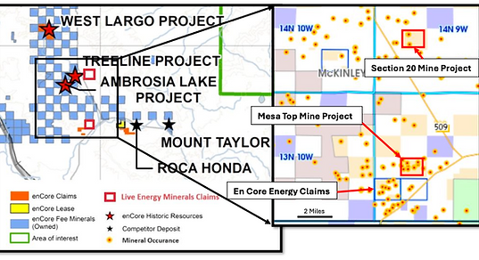
About the Section 20 Project
Located within the Ambrosia Lake Subdistrict on BLM land located with LODE claims, Section 20 produced an estimated 7.7 million Pounds U308 between 1962 and 1970.
Featuring an overall depth of 333.45m, the geology of the project consists of regional Ambrosia Lake Dome structures found in two horizons as primary tabular ore occurring in the Westwater Canyon Member of the Morrison Formation.

About the Mesa Top Project
Mesa Top's claims are located within the Ambrosia Lake Subdistrict and historically produced 108,261 tons of ore between 1954 and 1968, with a total estimated production of 571K lbs U3O8.
Mesa Top's deposit occurs within the Poison Canyon Sandstone of the Brushy Basin Member of the Morrison Formation. Hosted within Sedimentary Rock and featuring Uranium, Vanadium and Molybdenum.

